Green Infrastructure Code Audit Help
Question #2. What is the minimum roadway width allowed for streets in low volume roads (less than 400 daily trips)?
Example: 9-12 feet for local roads, not counting bike or parking lanes. See: Albany Complete Streets Design Manual 5-19
Question #3. Are parking lanes allowed to also serve as traffic lanes (i.e. queuing streets)?
Example: streets designed so that moving cars must yield between parked cars. See: Oregon Neighborhood Street Design Guidelines
Question #4. Do connected streets promote the most efficient street layouts that reduce overall street length? (i.e. grid plan)
Examples: Why the grid is a great asset
Question #5. Does your code allow for a connective pedestrian path, in lieu of vehicular streets between neighborhoods or commercial sites?
Examples: Stormwater Coalition Model Code Model Community Action Level
Question #6. Does your community have an official multi-use trail plan?
Example: City of Pendleton Multi-Use Trail Plan
Question #7. Has your municipality adopted Complete Streets Legislation?
Example: City of Troy’s Complete Streets Code
Question #8. Does your municipality’s residential subdivision regulations require new streets to incorporate stormwater retention, detention, and/or infiltration features?
Example: Stormwater Coalition Model Code Gap 6, Section 5.1(c) Facility Design Standards
Stormwater Coalition Model Code Gap 6, Section 5.2 Building Roof Drains
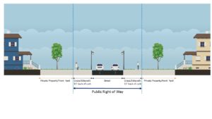
Question #9: What is the minimum right of way (ROW) width for a residential Street?
Example: The width of a road and sidewalks, as well as the green space between the two, that is reserved for public use. Beyond the right of way is typically a private property.
Question #10: What is the maximum radius allowed for cul-de-sacs?
Example: Stormwater Coalition model codes
“The outside turning radius of cul-de-sac may not exceed 35 feet unless determined necessary and recommended by the Town Highway Superintendent.”
Question #11: Can a landscaped island be created for a cul-de-sac?
Example: Stormwater Coalition model codes Best Management Action Level 2.2 (c)
“Centers of cul-de-sacs shall consist of pervious surfaces including: pervious pavement, porous pavers, grass, structural grass to accommodate emergency vehicles and trucks, low-growing bioretention areas, rain gardens, trees or other permeable stormwater treatment measures approved as part of a stormwater pollution prevention plan.”

Question #12: Does your code require pedestrian walkways between cul-de-sacs

“Cul-de-sacs shall include pedestrian connections to abutting streets wherever practicable as shown in Figure 5-4.”
Example: walkable subdivisions 11. Requirements for Cul-de-sacs.
Question 13: Are sidewalks always required to be on both sides of the street?
“It is recommended that sidewalks are considered for both sides of a roadway where pedestrian traffic is present or anticipated.”
Example: Design Guidelines for sidewalks
Question 14: Are sidewalks encouraged to be sloped to drain to the front yard instead of the street?
“Sidewalks shall be graded such that they drain to the front yards except in areas where the introduction of additional groundwater may be undesirable.”
Example: Gap 8- Sidewalks and curbs, 2.1 Sidewalk Design (b)
Question 15: Is there a maximum driveway width specified
Minimum- 10 feet
Maximum- 25% of frontage
Example: Driveway width
Question 16: Can pervious materials be used for single family home driveways? (e.g. grass, gravel, porous pavement, etc.)
What are “pervious materials”? Pervious materials permit water to enter the ground by virtue of their porous nature, or by large space in the material. This helps reduce stormwater runoff as more water is naturally absorbed into the ground.

“Off-street parking areas and driveways accessory to single-family and two-family dwellings. Notwithstanding the provisions of a subdivision, off-street parking areas and driveways accessory to a single-family dwelling may be surfaced with pervious paving systems that utilize gravel installed and maintained per industry standards. Off-street parking areas and driveways accessory to single-family or two-family dwellings may be surfaced with pervious paving systems that utilize turf with plastic geocells or open-celled paving grids installed and maintained per industry standards and designed sot hat the parking of vehicles does not kill the turf.”
Code example: Amendment to Minneapolis zoning code
Question 17: Can a “two track” design be used at single family driveways? (grass or gravel in between)
Code example: Gap 5- 5.0 (h) Design Criteria
Question 18: Are shared driveways encouraged in residential developments?
Code example: Gap 5- 5.0 (g) Design Criteria

Question 19: Are driveways encouraged to be sloped to drain to yard areas instead of the street?
Example: Gap 6, 2.0 Minimum Action Level (a & b), Control of Rooftop Runoff
Question 20: Is the use of shared parking arrangements encouraged?
Example: Gap 1, 2.1 through 2.3, and 3.0 Shared Parking/ Model Law Parking Lot Design
Question 21: Are model shared parking agreements provided by the municipality?
Example: Gap 6, 5.5 Shared Parking
Question 22: Are parking ratios reduced if:
What is a parking ratio: The number of parking spaces available on a per-unit, or sometimes square footage, basis.
Example: mass transit is within a 1/4 mile (Gap 1, 2.4 (a) Proximity to Mass Transit
Example: Access to bicycle parking (Gap 6, 5.6, Proximity to Mass Transit)
Question 23: What is the maximum stall width & length for a standard parking space?
Example: Gap 1, 3.0 (e) Parking Lot Design
Question 24: Does your code require a certain number of spaces for:
Example: Gap 6, 5.4 (g) Parking Lot Design
Question 25: Do you require previous materials be used in any of the following cases?
Example: Gap 6, 5.4 Parking Lot Design

Question 26: Is there a minimum percentage of parking lot that is required to be landscaped?
Example: Gap 1, 4.0 (b & c) Landscaping
Question 27: Does your municipality allow the use of bio-retention areas and other stormwater practices within landscaped areas or setbacks?
What is bio-retention? Areas landscaped for catching and filtering stormwater before entering the ground. Bio-retention can be of any scale and consists of a grass buffer strip, sand bed, ponding area, organic layer, planting soil, and plants.
Example: Gap 6, 5.10 (b & i) Landscaping and Permeable Strips
Question 28: Are there any incentives for developers to build multi-level garages rather than surface parking lots?
Example: Density Bonuses
Question 29: Are parking requirements set as maximums?
Example: Parking Maximums- Portland Oregon
Question 30: Has the municipality identified and mapped critical natural resource areas?
What is a Natural Resource Inventory? An NRI compiles and describes important naturally occurring resources such as forests, wetlands, surface and ground waters, and farmland within a given locality.
Example: NYS DEC provides a guide on creating a NRI
Question 32: Does the local comprehensive plan contain any natural resource protection elements, with goals calling for preservation of any of the following:
Example: The City of Albany’s comprehensive plan provides strategies for preserving natural resources.
Question 33: Does the municipality have a floodplain management ordinance or local law that prevents filling in or new construction in the 100-year floodplain?
Question 34: Does your municipality have a local erosion and sediment control law?
Question 35: Which of the following does your code require?
Example: Gap 6, 4.0 & 4.2, Site Design Standards
Question 36: Does the municipality require that natural conservation areas are delineated and defined before site layout and design are conducted?
Example: Gap 6, 4.0 & 4.2, Site Design Standards
Question 37: Do regulations limit the total portion of the site that can be cleared?
Example: City of Albany code: 345-18
Question 38: Does the municipality require that conservation areas and native vegetation be protected in an undisturbed state during the design, construction, and occupancy stages?
Example: Gap 6, 4.2(g), Site Design Standards
Example: City of Albany 133-105 (B.2)
Question 39: Does your community impose stormwater requirements on proposed areas of disturbance smaller than one acre in size?
Example: CDRPC Green Infrastructure Toolkit
Question 40: Does the municipality have a stream buffer ordinance or local law?

Example: Gap 4, 2.4, Natural Resource Buffers
Question 41: Does the ordinance also regulate intermittent streams?
What is an intermittent stream? Streams that are only present hours or days after rainfall and wet seasons. These streams cease to flow for weeks and months at a time when weather is warm and dry.

Example: Gap 4, 2.4, Natural Resource Buffers
Question 42: Does the municipality have a local wetland buffer ordinance or local law?
Example: City of Albany code: 133-105, part 7
Question 43: Is there an ordinance that requires buffer zones between development and preservation areas?

Example: Buffer Protection and Management Ordinance, Baltimore County MD
Question #44: Do the stream and wetland ordinances specify low impact uses in the buffer that are compatible with conservation (such as passive recreation)?
Passive recreation definition: Non-consumption uses of space, such as wildlife observation, biking, walking, and canoeing. The objective of passive recreation is to limit the disturbance on ecosystems while enjoying the outdoors.

Example: Gap 5, 6.0 (h), Open Space Management/Cluster Development
Question 45: Do stream and buffer ordinances/local laws specify enforcement mechanisms?
Example: Fulton County Stream Buffer Protection Ordinance, Section 26-433
Question 46: Do stream and buffer ordinances/local laws specify education mechanisms?
Example: Albemarle County, Virginia’s property owners guide to stream buffers
Question 47: Do stream and wetland buffer ordinances/local laws specify that part of the buffer be maintained with native vegetation?
Example: Gap 6, 4.3 (a), Natural Resource Buffers
Question 48: Does the municipality have any of the following in the local zoning or subdivision laws, or construction policies?
Example: Open space design
Example: Conservation subdivision
Example: Cluster development
Question 48A: Are the review requirements for open space, conservation subdivision, or cluster development greater than those for convention development?
Example: Saratoga Springs- Chapter 241: Conventional Subdivision Review 241-5
Question 48B: Does the open space or cluster subdivision ordinance provide density bonuses when a certain percentage of open space is preserved (incentive zoning)?
What is a density bonus? Density bonuses create incentives for developers to provide public amenities in exchange for a greater density level than allowed under existing zoning. Amenities can include open space, low-income housing, etc.
Example: Gap 2, 2.0 Model Community Action Level (b)
Example: Jefferson County, MO Open Space Design and Density Bonus Standards
Question 48C: Does the open space or cluster subdivision ordinance require that open space areas associated with development be connected or consolidated into larger units?
Example: Saratoga Springs- Chapter 241: Subdivision Regulations, Section 241-12 (c.2.d)
Question 49: Are critical natural resource areas deducted from the total acreage count that is used to calculate density?
Example: Saratoga Springs- Chapter 241: Subdivision Regulations, Section 241-12
Question 50: Are flexible site design criteria available for developers that utilize open space or cluster design options?
What is “flexible development”? A form of residential development allowed by right with site plan review, whereby the options of common driveways and flexible area and frontage requirements are used to create permanent open space and as an alternative to current state and local development regulations.
Example: Town of Worthington, MA Flexible Development, Section XIII
Question 51: Does the municipality allow for irregular lot shapes to be created in order to preserve open space or habitat protection?
Example: Gap 5, 5.0 (e), Design Criteria
Question 52: Does a minimum percentage of open space have to be in a natural condition?
Example: Gap 5, 7.0 (3) Open Space Management/Cluster Development
Question 53: Does your ordinance permit management of open space by a third party, using land trusts or conservation easements?
Question 54: Are secure and permanent funding arrangements required for the long-term management and maintenance of open space?
Example: Gap 5, 7.0 (4) Open Space Management/Cluster Development
Question 55: Does your local law require that, if forests are present at residential development sites, stands have to be preserved?
Example: Gap 5, 5.0 (4), Design Criteria
Question 56: Does your municipality require boundaries of disturbance to limit clearing of trees and natural vegetative cover during construction?
Example: Gap 6: 4.2 (f – h), Site Design Standards
Question 57: Does your municipality require boundaries of disturbance to limit unnecessary compaction of beneficial soils?
Example: Gap 6, 5.10 (i,3), Model Community Action Level
Question 58: Does your municipality have an ordinance or local law that requires forestry best-management practices for timber harvesting and tree cutting?
Example: Clifton Park- Chapter 184, Section 5
Question 59: Does your municipality have requirements for preservation and replacement of trees?
Example: Gap 6, 4.4 Tree Protection
Example: Conservation Tools
Question 60: Does the municipality have a local open space fund through bonding, real estate transfer tax, or other funding mechanism to encourage open space protection?
Question 61: Does the municipality use local, county, state, or private open space funding for purchase or transfer of development rights programs?

What is a transfer of development rights program? An incentive based program that allows landowners to sell development rights from their land to a developer or other interested party who then can use these rights to increase the density of development at another designated location.
Example: NYS DEC Transfer of Development Rights
Question 62: Does the municipality provide information to landowners about reduced local tax assessment by any of the following?
Question 63: Has your community adopted a Green Infrastructure Design Manual to guide the installation of green infrastructure?
Example: NYS DEC Design Manual
Example: Albany Pool Communities Green Infrastructure Toolkit (designed for sites smaller than 1 acre)
Example: EPA stormwater factsheet
Question 64: Does your municipality set limits on peak flow rate from site stormwater discharge?
Question 65: Are curb and/or gutters required for new residential street sections?
Example: Gap 3, 2.1, Vegetated Open Channels
Question 66: Does your ordinance encourage the use of the following, in lieu of gutters?
Dry Swale: Dry Swale Design
SUNY Albany Dry Swale
Rain garden: NYS DEC rain garden guide
Right-of-way bioswale: NYC bioswale handbook

General GI practices: Albany Pool Communities GI tool box
Question 67: Is rooftop runoff permitted to be discharged to yard areas?
Example: Gap 2, 1.0 & 2.0, Rooftop Runoff
Question 68: Do current grading or drainage requirements allow for temporary ponding of stormwater on yards?
Example: Gap 6, 2.0 Minimum Action Level (a,b), Control of Rooftop Runoff
Question 69: Do current grading or drainage requirements allow for temporary ponding of stormwater on rooftops?
What is rooftop ponding? AKA “blue roofs” or rooftop detention
Example: Gap 6, 2.0 Best Management Action Level (a,b), Control of Rooftop Runoff
Question 70: Does your municipality have a program to disconnect rooftop drains?
Example: Pioneer Valley Sustainability Toolkit
Question 71: Does your municipality’s zoning and subdivision regulations specifically permit green infrastructure practices including, but not limited to:
Question 72: Does your municipality’s local stormwater management regulations allow for off-site stormwater management?
Question 73: Do local plumbing codes allow harvested rainwater for uses such as irrigation and cisterns?
Example: EPA best practices for rainwater harvesting
Question 74: Do local regulations encourage green infrastructure practices in Combined Sewer Overflow (CSO) areas?
What is a combined sewer overflow? A combined sewer overflow system collects rainwater runoff, domestic sewage, and industrial wastewater into one pipe. Under normal conditions, it transports all the wastewater it collects to a sewage treatment plant, then discharges to a water body. However, when rainwater is falling and collecting at a faster rate than the system can handle, it creates an overflow.
Example: EPA Greening CSO Plans
Question 75: Does the local government require a pre-site plan meeting with developers to discuss stormwater management and green infrastructure approaches?
Example: City of Norfolk Stormwater pre-construction meeting application
Question 76: Does the local government sponsor demonstration projects for green infrastructure management practices?
Example: DEC Rain Garden Demonstration
Question 77: Does the local government provide an informational brochure/manual for homeowners/agencies describing acceptable rainwater harvesting techniques?
Example: Oregon Department of Consumer & Business Services- Building Code Division Rainwater Harvesting
Question 78: Is your municipality cooperating in developing regional approaches to stormwater management and watershed protection?
Example: NYS DEC MS4 info
Question 79: Does your municipality provide information for Home Owners’ Association (HOA) on how to manage stormwater?
Example: Cumberland homeowners association
Question 80: Have areas of the municipality been zoned for higher density development based on the following:
Example: Greater Cleveland Regional Transit Authority, best practices for transit oriented development
Question 81: Does your ordinance differentiate between previously undisturbed, adaptive reuse, and infill sites?
Question 82: Does your municipality’s zoning code allow any of the following to encourage development within infill areas or vacant lots?
Question 83: Does your ordinance permit accessory dwelling units to increase density?
Example: Gap 4, Density
Question 84: Do local stormwater management regulations permit reduced on-site management requirements for projects that decrease total imperiousness on previously developed sites?
Example: Albany Pool Communities Green Infrastructure Toolkit